


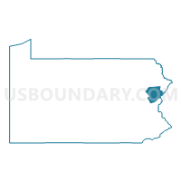
Monroe County PUMA, Pennsylvania
About
Outline

Summary
| Unique Area Identifier | 193843 |
| Name | Monroe County PUMA |
| State | Pennsylvania |
| Area (square miles) | 617.26 |
| Land Area (square miles) | 608.29 |
| Water Area (square miles) | 8.97 |
| % of Land Area | 98.55 |
| % of Water Area | 1.45 |
| Latitude of the Internal Point | 41.05623320 |
| Longtitude of the Internal Point | -75.32903690 |
Maps

Graphs
Select a template below for downloading or customizing gragh for Monroe County PUMA, Pennsylvania


Neighbors
Neighoring Public Use Microdata Area (by Name) Neighboring Public Use Microdata Area on the Map
- Carbon & Lehigh (North) Counties PUMA, PA
- Lackawanna (Outside Greater Scranton City) & Wyoming Counties PUMA, PA
- Luzerne County (East)--Kingston Borough PUMA, PA
- Northampton County (North) PUMA, PA
- Pike, Wayne & Susquehanna Counties PUMA, PA
- Sussex County PUMA, NJ
- Warren County PUMA, NJ
Top 10 Neighboring County (by Population) Neighboring County on the Map
- Luzerne County, PA (320,918)
- Northampton County, PA (297,735)
- Lackawanna County, PA (214,437)
- Monroe County, PA (169,842)
- Sussex County, NJ (149,265)
- Warren County, NJ (108,692)
- Carbon County, PA (65,249)
- Pike County, PA (57,369)
- Wayne County, PA (52,822)
Top 10 Neighboring County Subdivision (by Population) Neighboring County Subdivision on the Map
- Coolbaugh township, Monroe County, PA (20,564)
- Stroud township, Monroe County, PA (19,213)
- Chestnuthill township, Monroe County, PA (17,156)
- Middle Smithfield township, Monroe County, PA (15,997)
- Pocono township, Monroe County, PA (11,065)
- Lehman township, Pike County, PA (10,663)
- East Stroudsburg borough, Monroe County, PA (9,840)
- Penn Forest township, Carbon County, PA (9,581)
- Moore township, Northampton County, PA (9,198)
- Hamilton township, Monroe County, PA (9,083)
Top 10 Neighboring Place (by Population) Neighboring Place on the Map
- East Stroudsburg borough, PA (9,840)
- Arlington Heights CDP, PA (6,333)
- Stroudsburg borough, PA (5,567)
- Sierra View CDP, PA (4,813)
- Penn Estates CDP, PA (4,493)
- Indian Mountain Lake CDP, PA (4,372)
- Saw Creek CDP, PA (4,016)
- Mount Pocono borough, PA (3,170)
- Emerald Lakes CDP, PA (2,886)
- Wind Gap borough, PA (2,720)
Top 10 Neighboring Elementary School District (by Population) Neighboring Elementary School District on the Map
- Blairstown Township School District, NJ (7,663)
- Knowlton Township School District, NJ (3,055)
- Sandyston-Walpack Township School District, NJ (2,014)
Top 10 Neighboring Secondary School District (by Population) Neighboring Secondary School District on the Map
Top 10 Neighboring Unified School District (by Population) Neighboring Unified School District on the Map
- Pocono Mountain School District, PA (64,586)
- Wilkes-Barre Area School District, PA (59,879)
- East Stroudsburg Area School District, PA (47,915)
- Northampton Area School District, PA (41,714)
- Stroudsburg Area School District, PA (34,609)
- Pleasant Valley School District, PA (33,880)
- Nazareth Area School District, PA (27,963)
- Wallenpaupack Area School District, PA (25,535)
- Bangor Area School District, PA (22,655)
- North Pocono School District, PA (20,809)
Top 10 Neighboring State Legislative District Lower Chamber (by Population) Neighboring State Legislative District Lower Chamber on the Map
- General Assembly District 23, NJ (229,972)
- General Assembly District 24, NJ (215,703)
- State House District 189, PA (76,401)
- State House District 137, PA (72,979)
- State House District 176, PA (70,533)
- State House District 138, PA (68,208)
- State House District 118, PA (67,168)
- State House District 139, PA (67,006)
- State House District 122, PA (65,249)
- State House District 115, PA (63,002)
Top 10 Neighboring State Legislative District Upper Chamber (by Population) Neighboring State Legislative District Upper Chamber on the Map
- State Senate District 16, PA (288,264)
- State Senate District 20, PA (273,416)
- State Senate District 18, PA (267,805)
- State Senate District 29, PA (260,093)
- State Senate District 22, PA (255,871)
- State Senate District 14, PA (250,131)
- State Senate District 23, NJ (229,972)
- State Senate District 24, NJ (215,703)
Top 10 Neighboring 111th Congressional District (by Population) Neighboring 111th Congressional District on the Map
- Congressional District 15, PA (721,828)
- Congressional District 11, PA (687,860)
- Congressional District 10, PA (669,257)
- Congressional District 5, NJ (666,551)
Top 10 Neighboring Census Tract (by Population) Neighboring Census Tract on the Map
- Census Tract 3010.01, Monroe County, PA (10,169)
- Census Tract 208, Carbon County, PA (8,642)
- Census Tract 3012.05, Monroe County, PA (8,153)
- Census Tract 312, Warren County, NJ (7,949)
- Census Tract 3013.01, Monroe County, PA (7,874)
- Census Tract 3003.07, Monroe County, PA (7,578)
- Census Tract 3004.03, Monroe County, PA (7,033)
- Census Tract 3001.02, Monroe County, PA (6,968)
- Census Tract 3003.04, Monroe County, PA (6,789)
- Census Tract 3004.02, Monroe County, PA (6,430)
Top 10 Neighboring 5-Digit ZIP Code Tabulation Area (by Population) Neighboring 5-Digit ZIP Code Tabulation Area on the Map
- 18301, PA (28,561)
- 18360, PA (28,362)
- 18013, PA (17,802)
- 18302, PA (17,362)
- 18466, PA (16,681)
- 18353, PA (12,779)
- 18428, PA (12,012)
- 18014, PA (11,387)
- 18071, PA (10,578)
- 18324, PA (9,714)